Tangsibje
Geographical and Climatic conditions
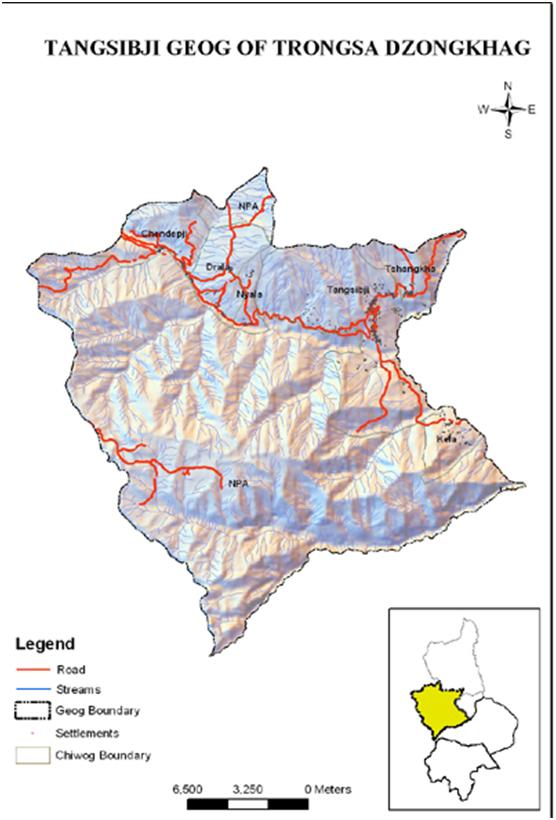
The Gewog Administration is located about 25 km away from Dzongkhag Administration, with a total area of 371.6 Km². The Gewog falls geographically to the west of Dzongkhag where it has Wangdiphodrang Dzongkhag to the west, Langthil Gewog to the south, and Drakteng Gewog to the east. The gewog enjoys a warm and wet summer, while the winter months are dry and cold, with an altitude ranging from about 1600 meters to 2600 meters above sea level. The east-west highway runs through the Gewog and acts as a main artery for economic development.
Chiwogs and basic Infrastructures
The Gewog comprises five Chiwogs namely; Chendipji, Kela, Nyaladrangla, Tangsibji and TshangkhaChiwogs respectively. The Gewog consists of nine villages with 235 households and 2389 population as per the Gewog census record. Other than the RNR office which is located at Tashiling, BHU II at Tashilingand Sub-post at Kela provide basic services to the people of the Gewog. The Gewog has a Tshangkha Central School, Chendipji primary school, and Kela ECR to provide a conducive learning platform to the students.
Tangsibji Hydro Energy Limited (THyE), a 100 % subsidiary company of Druk Green Power Corporation Limited for the implementation of the 118 MW Nikachhu Hydropower Project is located towards the east of the Gewog.There are two micro hydel in the Gewog, one at Chendebji and another at Tangsibji village. Micro-hydro at Tangsibji village was established in 1987 with a generating capacity of 0.03 MW and it benefits 53 households. Micro-hydro at Chendebji was establishedin 2005 with a generating capacity of 70 KW and benefits 31 numbers of households. All the villagers are now connected by electricity supply.
Biodiversity
Tshangkha, Tangsibji, and Kela Chiwogsfall within Jigme Singye Wangchuck National Park with rich biological diversity. NyalDrangla and the majority of Chendipji Chiwog fall under Forest Management Unit. The forest is home to various animals and birds including the endangered tiger. The forest is also enriched with varieties of tree species that can be used for various purposes, as well as various non-wood forest products potentially playing an important role in promoting rural livelihoods thereby alleviating the poverty of the local community.
Agriculture
The majority of the population is dependent on agriculture as the main source of livelihood. Paddy is the staple cereal crop that is cultivated on a large scale by the public of Tangsibji and Kela Chiwogs. Whereas, for Tshangkha, Chendebji, and Ngaladangla community, potato is the main cash crop. The farmers of Kela Chiwog, have started growing cardamom, and people have now started to emphasize working more as it is found to be more profitable. As per the Gewog Agriculture data, TangsibjiGewog comprises of 437.601 acreage of wetland and 1054.291 acreage of dry land. In addition, there are 15 nos. of irrigation schemes with lengths measuring 36.5km and 18 nos of farm roads with lengthof 71.03km.
Livestock
Dairy farming is one of the main activities that the majority of the community is dependent on. It is also a main income generation activity of the people. Almost all people go for high-yielding cattle and the Jersey breed is being dominated by local cattle. There are 822 numbers of improved breed and 659 heads of local cattle respectively in the geog. There is one existing milk processing unit (MPU) at Tashiling whichis operated by Tangsibji dairy group members. There are 22 members actively contributing to dairy commodities to the MPU. The dairy products are being sold by MPU itself. In addition, the farmersgroup called the Contract Heifer and Bull Production Programme (CHBPP) also functions smoothly. The aim of this group is to promote and produce young jersey heifers and breeding bulls to improve breed development under this scheme. There are 69 group members from Tangsibji and Tshangkha Chiwogs. The livestock center also providesartificial insemination (AI) services to the community in order to intensify dairy development programs and breed improvement accordingly.
Culture and traditions
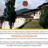
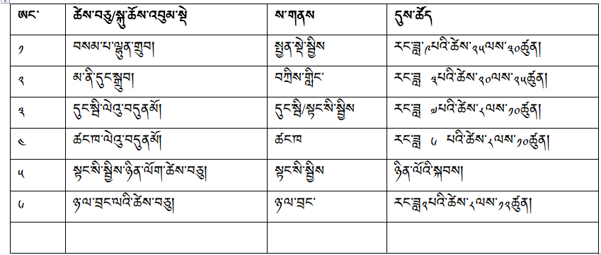
The Gewog is also enriched with diverse cultures and traditions. They celebrate various local festivals and other religious ceremonies (Table 2) where the community gathers together to witness the tshechus and do philanthropist activities. A sacred monument like Chendebji Chorten is located within this Gewog which lulls immense numbers of tourists.
Lhakhangs
There are 12 lhakhangsof which 7 are private and 5 are community-owned. TashilingZorigand TshangkhaShedra which are taken care of by dratshang are also located in the gewog.
Table 2: Detail of local festivals and religious ceremonies
.